NASA satellite captures Super Typhoon Bavi’s eye illuminated by moonlight
A NASA-supported satellite captured a rare nighttime image of Super Typhoon Bavi's eye illuminated by moonlight as it neared peak intensity.
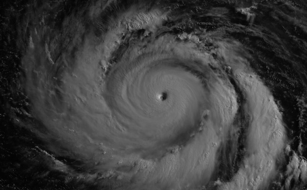
A rare nighttime satellite image has captured Super Typhoon Bavi’s eye illuminated by moonlight, offering an unusually striking view of the storm as it approached peak intensity over the western Pacific.
The image, taken shortly after midnight local time on July 6, was collected by the Visible Infrared Imaging Radiometer Suite aboard the NOAA-20 satellite. It showed the storm’s eye surrounded by a tightly organised eyewall, with moonlight illuminating part of the cyclone from above at a moment when Bavi was near peak intensity. Several hours later, the eye moved across Rota, one of the islands in the Northern Marianas, with the satellite view highlighting how compact and well-defined the storm had become as it travelled westward across unusually warm ocean waters.
Bavi reached super typhoon status on July 4 local time, with sustained winds climbing to around 290 kilometres per hour by the time it approached Guam and the Northern Mariana Islands — making it the third Category 5 tropical cyclone of 2026, according to NASA.
By July 8, satellite imagery showed Bavi moving west across the Philippine Sea, southeast of Taiwan, with maximum sustained winds still estimated at around 250 kilometres per hour despite signs of gradual weakening. Forecasts suggested the storm could curve northwest, potentially affecting Taiwan, the Ryukyu Islands of southern Japan and parts of mainland China.

Leave a Reply