Scientists Just Mapped the Sky’s Hidden Water Highways for the First Time
A new global study has mapped, for the first time, the ocean regions where atmospheric rivers gather the moisture that later fuels destructive floods.
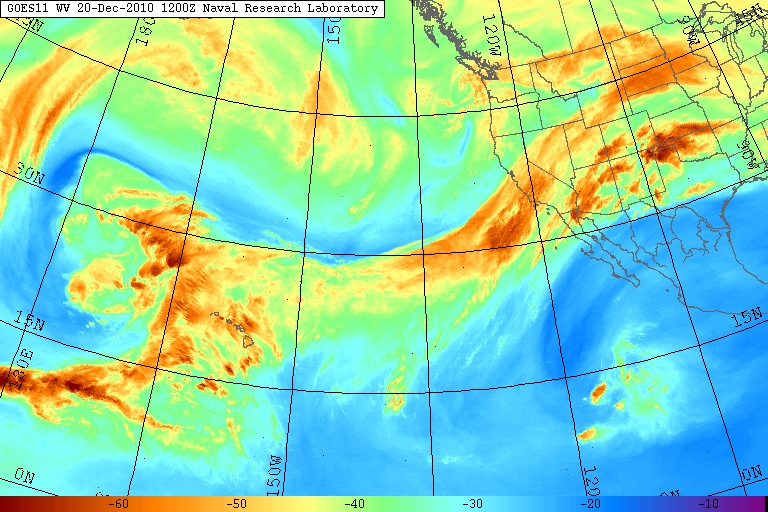
Atmospheric rivers move more water through the sky than every surface river on the planet combined, and for decades scientists could describe what they do without fully knowing where they begin. A new global mapping study, published in Climate and Atmospheric Science, has now traced these airborne waterways back to the specific ocean regions where they pick up their moisture, filling a gap that has long limited how far in advance floods can be predicted.
The research team analysed more than 40 years of global atmospheric data, combining satellite observations, weather reanalysis datasets and advanced computer modelling to track how atmospheric rivers evolve across their entire lifetimes. Rather than gathering water evenly along their path, the study found that these systems draw most of their moisture from a limited number of ocean ‘hotspots’, where warm sea-surface temperatures and favourable wind patterns drive intense evaporation.
Among the most significant of these hotspots are stretches of ocean in the eastern Indian Ocean and western Pacific near Australia. Moisture picked up here can travel enormous distances, reaching Australia, New Zealand, South America or even Antarctica depending on prevailing weather patterns. Some atmospheric rivers draw from several such regions during their journey, while others rely almost entirely on a single source.
The scale of what these systems move is striking: researchers found that atmospheric rivers are responsible for transporting nearly 90% of all water vapour that travels from the tropics towards the poles. They can stretch for thousands of kilometres while remaining just a few hundred kilometres wide, concentrating enormous volumes of moisture into narrow corridors of sky.
The danger arrives when that moisture is forced upward, whether by mountain ranges or colliding weather fronts. The vapour cools, condenses, and falls as heavy rain or snow, and if an atmospheric river stalls over land, the result can be prolonged, intense downpours that trigger flooding and landslides. Australia, California, western Europe, South America and New Zealand have all experienced billion-dollar flood disasters linked to these systems.
By identifying exactly where atmospheric rivers gather strength before making landfall, researchers believe forecasters could gain valuable extra lead time, watching ocean moisture ‘fueling stations’ rather than relying only on conditions near the coast. The team also notes that as oceans continue to warm, higher evaporation rates could feed these systems even more moisture, a factor that may shape how destructive future atmospheric rivers become.
Image credit: Wikimedia Commons


Leave a Reply